
Laguna de los Tres: Cerro Fitz Roy
Santa Cruz province is located in the southern part of the country, in Patagonia and it is the second largest in Argentina but with the smallest population per square kilometer. Most of Santa Cruz is dry grassland or semidesert, with high mesetas ( plateaux ) interspersed with protected valleys and covered with large sheep estancias. To the west, the Andes at these latitudes are lower than in the centre and north of Argentina, but still have year-round snow. An immense ice sheet feeds the numerous glaciers.
From the centre to the Atlantic coast in the east, plateaux of descending height dominate the landscape. The Atlantic coastline is a mixture of beaches and cliffs. In Gran Bajo de San Julián, the Laguna del Carbón is 105 meters below sea level, and is the lowest point in the Western and Southern Hemispheres.

From the centre to the Atlantic coast in the east, plateaux of descending height dominate the landscape. The Atlantic coastline is a mixture of beaches and cliffs. In Gran Bajo de San Julián, the Laguna del Carbón is 105 meters below sea level, and is the lowest point in the Western and Southern Hemispheres.

Climate in Patagonia
The province's climate is dominated by several different climatic regions. The extreme northeast coast is by far the mildest area, with summer temperatures ranging from 21ºC to 23ºC (70F to 73F) during the day and 8ºC to 10ºC (46F to 50F) at night, and winters ranging from 8ºC to 10ºC (46F to 50F) during the day and 0ºC to 2ºC (32F to 35F) at night. Precipiation is scarce, at about 200 mm, snow is rare, as well as temperatures below -10ºC (14F). The central and southern coast are progressively cooler and wetter. High temperatures in the summer range from 18ºC to 21ºC (64F to 70F) with nights between 7ºC and 9ºC (45F to 48F) and extremely high winds, whereas winters average 4ºC to 7ºC (39F to 45F) during the day, and -3ºC to 0ºC (27F to 32F) at night.
Patagonia Tours
Fitz Roy Massif
If you visit El Calafate in Argentina, you should not miss one of the most impressive peaks in the Andes, Monte Fitz Roy ( 3,406 meters/11,175 ft ). In good weather, Fitz Roy can be seen from El Calafate. ( 136 miles, 219 km south from Fitz Roy mountain ).
Patagonia Wild Trails is the most popular program among passengers seeking for outdoors activities that wish to go one step beyond a moderate trek. No previous technical requirements are necessary. In Fitz Roy area we trek from north to south visiting Fitz Roy massif and Cerro Torre group (probably two of the most beautiful mountains on Earth) and we end hiking up to Paso del Viento to have a good look to the Patagonian Ice Field. With the extra bonus of one day of glacier hike in the Cerro Torre glacier. In Paine National Park we trek the 3 valleys of the famous "W" circuit.

The best base for visiting this part of the Parque Nacional Los Glaciares is the village El Chalten, 56 miles west, off RN40, above the western end of Lago Viedma. The village, whose name means “blue mountain”, the Amerindian name for Fitz Roy, nestles in a hidden bowl at the foot of the mountain, with its glacier coming down off the Southern Patagonian Ice Field. The village has expanded rapidly in recent years due to its ever-growing popularity with visiting trekkers and mountain climbers.


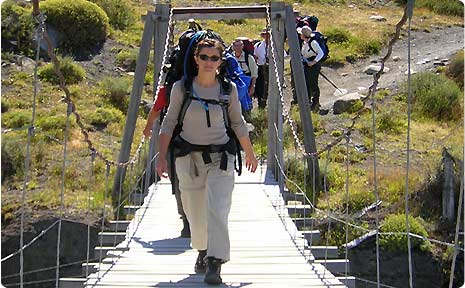
Trek to Laguna Los Tres
The trek to Laguna Los Tres allowed us to have the best available view of Mount Fitz Roy. We followed the Fitz Roy Trail up to Rio Blanco, passing Poicenot, the mountaineering camp. Finally, a short but steep trail will take us to Laguna de Los Tres. The turquoise-blue of the Lagoon is a stunning sight and this is of course magnified by the accompanying view of Fitz Roy’s spires and glaciers. The group returned to El Chalten in the afternoon.
Cave Paintings
South of the Perito Moreno town in Santa Cruz province, is the Cueva de las Manos
(Cave of the Hands), a national historical monument and World Heritage Site located in a beautiful canyon 56 km ( 35 miles ) off RN 40 from must north of Bajo Caracoles. Pre-Columbian cave paintings are found all over Santa Cruz, but those at Cueva de las Manos are the finest. The walls here are covered by paintings of hands and animals, principally guanacos ( relatives of the llama ), which are thought to be anything between 3,000 and 10,000 years old. Numerous lakes straddle the Argentine-Chilean border in the region.


Parque Nacional Perito Moreno ( not to be confused with the town of the same name ) is the next major stop, 72 km ( 45 miles ) to the west of RN40. In the distance is Monte San Lorenzo, the highest peak in stana Cruz at 3,706 meters ( 12,150 ft ). Within the park are lakes Belgrano and Burmeister. Near the latter is the Casa de Piedra, a strange rock formation with ancient paintings.
Upsala Glacier
The second major trip from El Calafate is a visit to the Ventisquero Uspala, at the far nothr west end of Lago Argentino. Bats leave every morning from Punta Bandera ( 40 km/25 miles ) west of El Calafate. In early spring, they cannot get near Upsala because of the large field of icebergs, so may visit Spegazzini and Onelli glacier. On the way back, we strongly recommend a stop at Estancia Alice on the road to El Calafate. Asados ( barbecues ) and tea are available here and shearing demonstrations are held in season. You may also see black necked swans and other birds.
It is only a short distance across the Sierra Los Baguales, Argentina, to Parque Nacional Torres del Paine, in Chile. From some spots near El Calafate, the Paine Mountians can be seen.
Paine & Fitz Roy are the best two hikes in Patagonia.
For further information about Patagonia and the major attractions in Santa Cruz State ( Argentina ) and Chilean Patagonia, contact us and we will send you update and useful information about these destinations.

1 comment:
the patagonia tours are spectacular
Post a Comment